


The Source to the Lodging House
From Izumi City to Hoshiya along the Kii-ji route of the Kumano Kodo

The Source 泉
Before persisting with my southerly route along the Kumano Kodo, I called in at the Museum of Yayoi Culture. The Yayoi period began in the third century BCE and continued until the third century CE. Somebody had told me the museum was boring, but it turned out to be pretty good. They even had audio guides in English, and just for my pleasure, lots of models.
It was the Yayoi era that marked the beginning of rice cultivation in Japan. Somehow, somebody brought the idea of cultivating rice from the Asian continent and Japanese settlers too began hammering wooden ‘arrow-boards’ into the ground to create neat causeways and fields that could be flooded and drained.
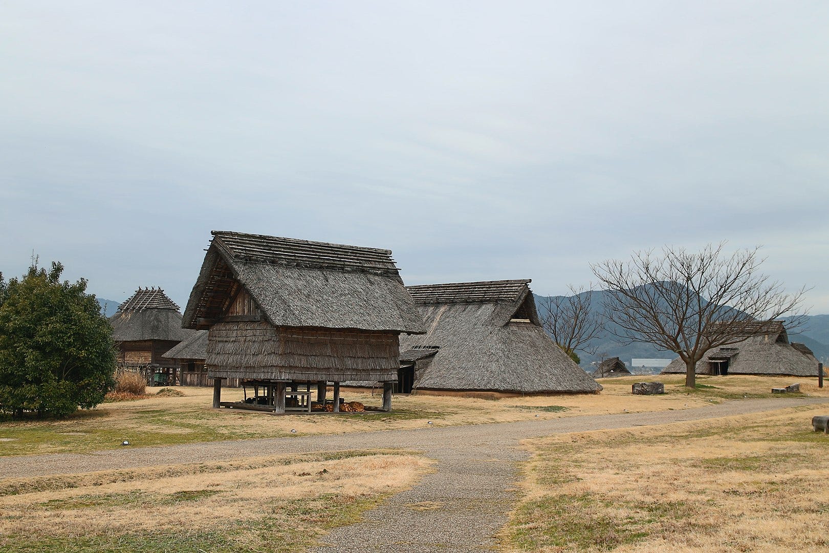
Near the museum is a park containing an example of a Yayoi settlement. Among the withered yellow grass, huts thickly layered with thatch almost to ground level surrounded a store-house with a raised floor.
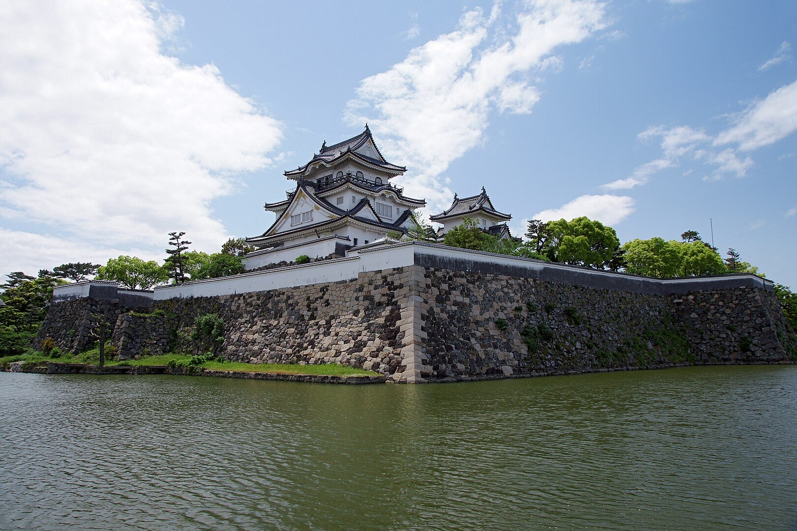
In relentless heat I moved on from Izumi City and headed into the castle city of Kishiwada. Construction of Kishiwada Castle began in 1585, but unfortunately the donjon, the main castle building, was struck by lightning and burned down in 1827. The current Kishiwada Castle is a concrete reconstruction from 1954
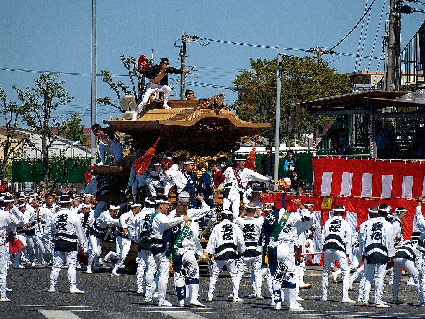
Kishiwada is famous for its danjiri festival. This is something of a cross between a traditional Japanese street festival, with tall floats pulled by headband-wearing men, and the running of the bulls. The floats are pulled at top speed around the streets of Kishiwada; frequently when cornering, they crash sideways into street furniture and shop fronts. Injuries are common and in some years there have even been deaths at this festival. It’s a chance to let all those sarariman frustrations loose once a year.
The route of the Kumano Kodo passed far from the castle, I couldn’t even see it. Along the eastern outskirts of Kishiwada I walked through an area of light industry and love hotels, cut through by rivers draining from the Kongou Sanchi mountain range on my left. A huge plastic milk bottle on a warehouse roof announced the presence of a Mainichi (Everyday) milk distribution centre.
I sheltered under an underpass and moved on into an old residential area. The old houses were broken up by some of the ugliest modern buildings I had ever seen. Japan has a passion for covering its concrete apartment blocks with tiling, giving the unfortunate reminder for Westerners of a public toilet. The tiling I had got used to, but one building had taken it a step further by having exceedingly ugly drainpipes running down the exterior; there was no attempt to make them more discreet — indeed they had been painted a bright pink. An office building reminded me of a World War Two concrete pillbox I had seen on the Lincolnshire coast, but somehow this was uglier; the architect had tried to break up the slabby concrete surfaces with grille-like concrete mouldings. The concrete now darkened with age, they succeeded only in making the building look more military.
Kishiwada to Izumi Sunagawa
From eastern Kishiwada I had to follow Route 30, a main road. It dipped into an overgrown valley before veering under a railway bridge. There were no pavements under the bridge, leaving me exposed to trucks squeezing through the narrow gap. The Kumano Kodo route actually forked off to the left before the bridge down a cool shaded lane. Unfortunately this route had been severed by the extended platforms of a railway station; I had no choice but to go down under.
I tired rapidly of the main roads; I took shortcuts down back alleys, where onions hung drying under the eaves, for momentary respite. The glistening slabs of airport hotels were visible through the heat haze. Now there were occasional fields, a factory making thick wire coils was split by the road, across which a busy fork-lift with a single proboscis scuttled back and forth.
This got me thinking, ‘What do you call a fork-lift with only one prong? What do you call a fork with only one prong? A spear? A spear-lift?’
I stopped for a drink among fields of rice that were just turning the faint yellow-brown that signalled their ripeness. The fields were covered with netting strung over fence-posts with newspaper-covered tops like old jam jars. The playing-card-spade-like heads of taro bobbed in the stifling breeze as I gulped cold green tea. Today would be a long hike, I had started earlier than usual, and I was beginning to get hungry.
Off the main road, the Kumano Kodo went through a sudden well-marked section. Old stone markers remained and there was even a more modern wooden sign. The problem was I needed somewhere to eat. At one time there must have been lots of places to eat along the Kumano Kodo, but the arrival of the motor car had changed that. Now there were no restaurants in the old areas, most eateries lay along the big four-lane highways: chain family restaurants like Big Boy and western burger bars. A sign pointed to a McDonald’s, but it was 1 kilometre along a major road running at right-angles to the Kumano Kodo. I couldn’t afford such a long detour.
There was no choice but to carry on, I came level with Kansai Airport and its attendant hotels and then left them behind as I entered a more rural area. Eventually, in the middle of a residential area I came across a Sylvanian Families hut. This was a family-run restaurant, and I entered with relief. Exhausted I sat and thought about my order. There were only two other customers. ‘Should I choose the hamburger? No, it was filling, but what if I gave credence to the Japanese stereotype that all westerners eat fast food all the time? But why should I care?’ I could sense the scrutiny of the other customers and the staff. I ordered the hamburger set menu and a drink in my best Japanese.
I ate carefully but dropped a little rice from my chopsticks. What if I was giving the impression that westerners really couldn’t use chopsticks? I subtly picked up the spilt rice making sure nobody was looking. There are so few foreigners in Japan that for residents like me there is a constant feeling that you are representing all foreigners. A paranoia develops about confirming stereotypes and you begin to feel the social pressure that the Japanese themselves feel in such a group-oriented society.
Refreshed from my meal but with tired feet, I walked along narrow roads with tile-topped walls. In places the daub on the walls was crumbling and revealing the rice-straw binding. There was a definite rural feeling — I was out of the city at last. A vista of flat rice paddy opened up and revealed the Kongou Sanchi Mountains closing in on my left, and ahead the low foothills of the Izumi Mountains.
Imagine for a moment a ballet dancer daintily pointing her foot out. Concentrate on her lower leg. Now imagine this same ballet dancer has a muscle-wasting disease that has left her calf withered and painfully thin (OK, she would have given up the ballet dancing long before this happened, but you catch my drift). The Kongou Sanchi Mountains are the ballet dancer’s ankle area and the Izumi Mountains are her foot. The Kongou Sanchi Mountains and Izumi Mountains form a curved barrier that divides the Izumi coastal plain from the Kinokawa river valley in which Wakayama City sits. To the north of the Kongou Sanchi Mountains there is a small gap beyond which lies the ballet dancer’s shin – the Ikoma Sanchi Mountain range. These mountains form a ridge separating Osaka and the Izumi coastal plain from the inland Nara plain.
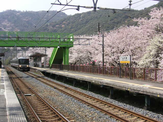
The next stage of the walk would mean crossing the Izumi Mountain range and descending into the Kinokawa valley. But first I would need to wiggle my way through the foothills. The road meandered around the low hills and giant golfing centre nets. I rested at an archaeological site behind a pink pachinko parlour with a giant dinosaur on its roof. Finally, I passed through more government housing projects and I reached Izumi Sunagawa station and my train home.
Izumi Sunagawa to Hoshiya
Frogs hopped and splashed in the drainage channels alongside the road as I set off from Izumi Sunagawa. As the road carved through a small hill, I noticed that the soil was indeed pretty sandy around here as the Sunagawa (sandy river) name suggested.
I was looking forward to today’s walking, partly because I would soon be in a part of the Kumano Kodo that was properly mapped, but also because I knew I would have a chance to see a right-wing battle bus at close quarters. On my train journeys between Wakayama City and Sakai I had seen one of these loudspeaker-topped black buses parked in some fields in a field near to Yamanakadani, a village nestled in the Yamanaka valley. Why was this little mountain village such a hotbed of right-wing extremism? I was determined to find out.
I tried to find a temple and large camphor tree mentioned in a guide, but succeeded in finding neither. The streets were too narrow and winding, and though I could see what I thought was the tree, I couldn’t reach it and couldn’t afford to lose time trying to find it. Today would be a long slog to Hoshiya in the Kino valley.
As I stood on a bridge trying to find my bearings, I disturbed a black and yellow striped lizard with a bright blue tail sunbathing on the concrete parapet. In fields on either side of the road rice had been harvested and was now drying on long trestles set up in the fields. The road wound its way up between steep pine-clad slopes.
I noticed some red flowers growing on the grass embankments of the fields. I remembered them from the same time the previous year. Further research revealed they were the autumnal-equinox flower which can only be seen for a brief period in late September. As I moved on the edges of the paddy fields were brushed with a deep pinkish-red hue.
I reached Yamanakadani in good time; I went to check out the right-wing bus first of all. Unfortunately it was on the other side of the railway line, and only a major detour would allow me to see it at really close quarters. The kanji on the sides of the bus were so heavily stylised that possibly even Japanese people would have trouble reading them. This left me no chance. My camera phone didn’t have the power to capture something so far away, so I had to leave the bus without any possibility of reading what was on it. It could just be a bus for the equivalent of the local round table after all.
The first properly marked oji was the shrine in Yamanakadani. I greeted the elderly man sweeping outside the gate, but he just looked at me and failed to return the greeting — definitely a fascist.
I saw plenty of hikers setting off from Yamanakadani, but very soon I lost them. It soon became clear why; the main highway along which I was walking became very dangerous. There was no pavement and the sides of the roads were overgrown with the Japanese equivalent of brambles. They really resembled brambles too, smarter versions of those in England and less thorny. I was even tempted to eat the berries, already ripe in places and looking just like English blackberries (It’s a good job I didn’t, because they’re actually very poisonous).
After a drink from a spider covered vending machine I crossed my first prefectural border on foot. A large marker stone announced the boundary between Osaka and Wakayama Prefectures. I was making progress!
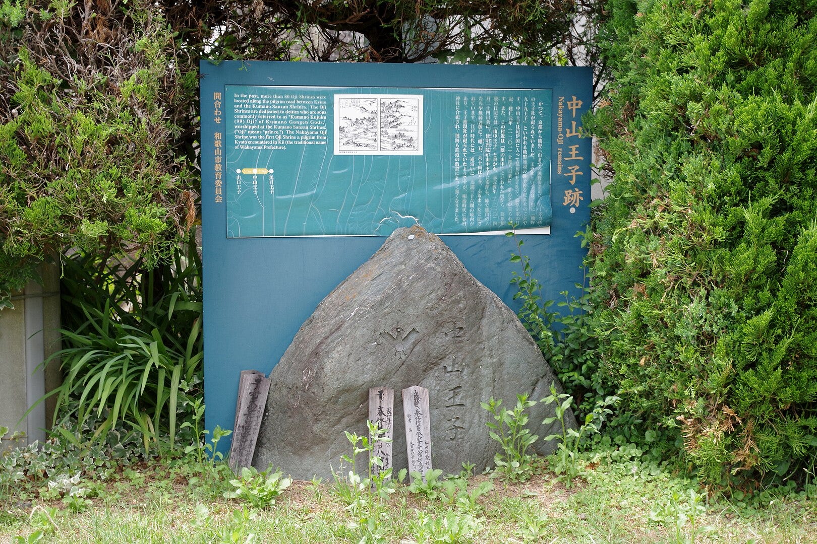
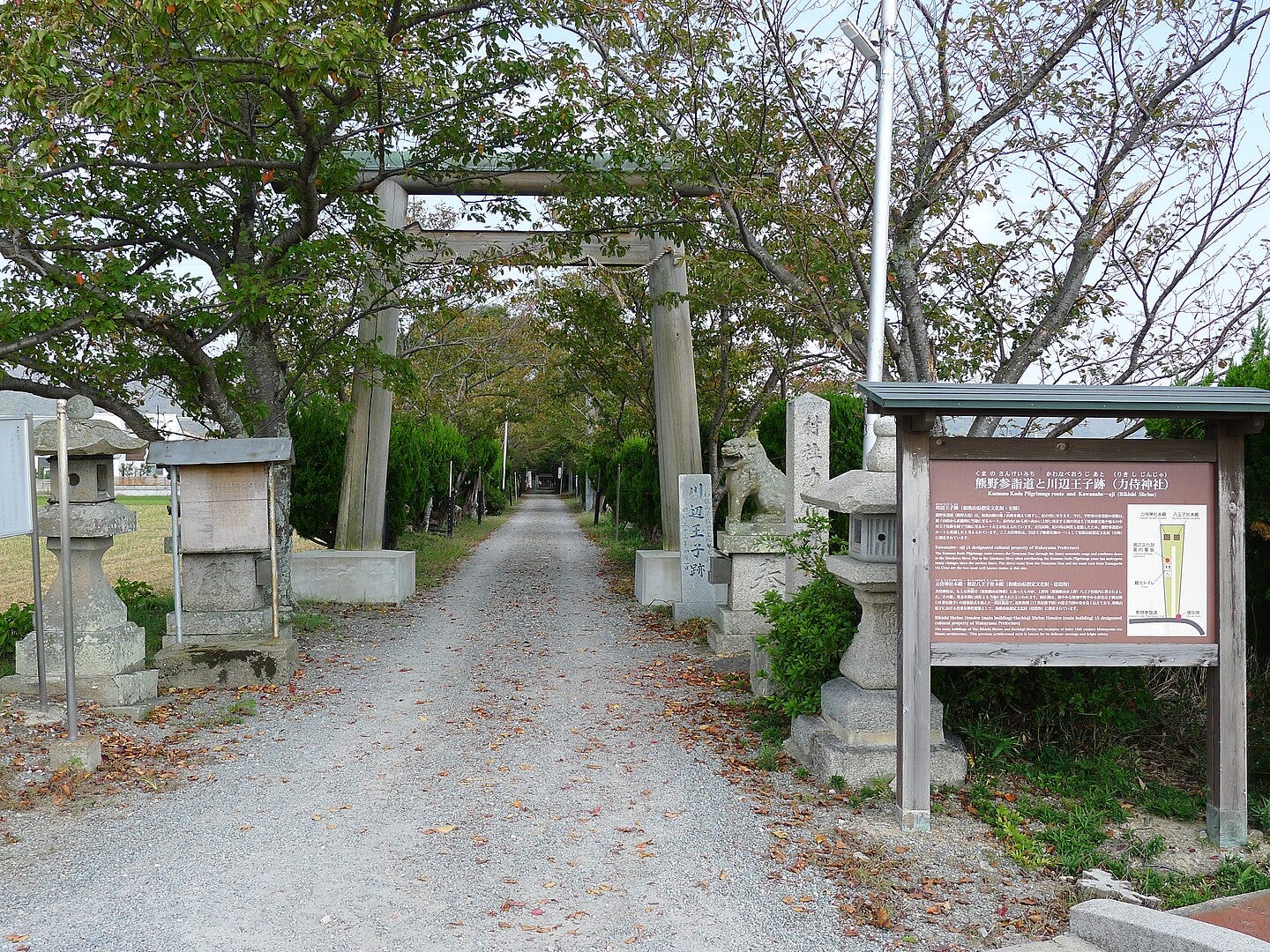
I had a break from Highway 64 as the Kumano Kodo route passed through a little hamlet on a tiny road. The first oji site in Wakayama Prefecture had a large blue board giving information about the oji as well as useful pictures showing what the area used to look like. This was the first of many such signs that are placed at oji shrines in Wakayama Prefecture and they proved highly useful for the remainder of my walk.
To return to Highway 64 I had to cross over the main railway line (the one I had used to get to my job in Wakayama City) which runs from Osaka along the coast of the Kii peninsula. There are an incredible number of level crossings in Japan and the bing bing bing sound of the crossing gates coming down is one of the most familiar sounds in the country. This crossing was right next to a tunnel along a sharp curve, so there was little chance of seeing or hearing oncoming trains. I put my life in the hands of the technology that makes the bing bing bing gates work at the right time and crossed the track.
I survived that, but Highway 64 only continued to get more hazardous. It wriggled like a trapped snake forcing me to make decisions about which side of the road was safer, would cars see me better on the outside of the bend or would the extra space on the inside of the bend afford greater protection?
Passing beneath the giant concrete pillars of the Osaka to Wakayama motorway I noticed that the bases of some of the pillars were cracked; I made a mental note not to be driving over this stretch of road when the big one struck.
Highway 64 began its descent into the Kinokawa valley; from the vertiginous edge of the highway I saw another road far below me. Only gradually did it dawn on me that this was the same road that I was on. A series of hidden hairpin bends overhung by the steep slope and pine trees dropped the road to the valley floor. The motorway meanwhile, too big to be dropped so rudely, descended gradually balancing on metal trusses.
On the valley floor I passed another oji, and from the cool shade of pine trees I emerged again into the fierce sun. There were new crops to be seen: aubergines hung from vines in dusty fields on the lower slopes.
Japan really isn’t designed for pedestrians in places. As I began to cross the paddy fields of the valley floor along a main road, the pavement disappeared; this wouldn’t have been so bad except for the leg-breaking cliff and drainage channel that marked the side of the road. There was no barrier to reduce the likelihood of tumbling into this concrete mantrap so I literally walked a precarious line between serious injury by falling and serious injury by motor vehicle.
Fortunately the Kumano Kodo removed itself from this hair-raising predicament and gave me the most pleasant section of the walk so far. It weaved its way along tiny maze-like streets among old farming houses, and then began to cross the open paddy fields on raised banks. The atmosphere reminded me of the Cambridgeshire Fens, the irrigation channels and sluice gates, harvesters at work in the fields, even the pale green-yellow colour and the flatness of the landscape.
A shrine lay in the midst of these fields at the end of a straight tree-lined track. I went to have a look at it and rested on a picnic bench beneath the shade. There was little to see except a large taiko drum but while I rested a man came striding up the straight track. He held a camera, strap swinging by his side.
I surreptitiously put some snacks in my mouth and slowly chewed them, I didn’t know if it was rude to eat at shrines or not, but I was starving. I knew I was approaching a major road, which meant this could be my best chance of finding somewhere to eat and rest before Hoshiya.
Sure enough, after a small detour up the dual-carriageway, I found a selection of eateries. I considered them for price and possibility of farce due to linguistic and cultural misunderstandings. I had three choices, a noodle restaurant, a buffet restaurant and a Korean food restaurant. The prices were similar, and the buffet restaurant clearly presented the greatest opportunity for cultural faux pas. I chose the buffet restaurant.
Actually the staff were helpful, although clearly this was the first time they had had a foreigner in their restaurant. I didn’t drop much food and wasn’t aware of making any major faux pas. Altogether it was a success; I was rested, full, and happy as I left the restaurant.
Now came the problem of crossing the Kino River. I wound my way across more narrow lanes towards the river embankment, but failed to see a way to the bridge that didn’t involve yet more tightrope walking between two versions of death along busy roads. I asked a farmer the way and he replied in surprisingly good English. When he wasn’t sure of the word he didn’t revert to Japanese (a trick I have yet to master when I am trying to speak Japanese) as most would, but did what most English people would do when they have forgotten a word — gestured and grimaced while making oohh and thingy noises. He helpfully pointed out a track and footpath which cut out the worst of the road-walking to the bridge.
During pilgrimage times there would have been no bridge here and pilgrims would have made their way across the river by ferry. The sites of the ferry crossing would have changed as the Kino River itself changed course over the centuries.
By the time I reached Hoshiya (lodging house) station, after once again losing my way, I had no energy to visit the final Oji on my map; I left it for my return to Hoshiya and boarded my one-man train to Wakayama City.
Another great story. How many kilometers did you manage to walk on this particular stretch?
Too bad you didn't show the ugly modern buildings.
This resonates. Not all walks are just along beautiful, well kept paths through delightful villages. We see real life. Keep safe but please keep writing.